Itasca State ParkLocation: central MinnesotaSize: 32,000 acresZIP: 56470
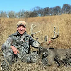
Central Minnesota, from Park Rapids to Brainerd, has some of the highest deer numbers in the state; some permit areas in the region harvest 10 to 13 deer per square mile, says big-game biologist Lou Carnicelli of the Minnesota Department of Natural Resources. Relatively limited road access and a ban on ATV’s and permanent deer stands make Itasca, Minnesota’s oldest state forest, a unique experience for this part of the state. “It’s not a drive-by deer hunt,” Carnicelli says, “it’s an opportunity to hunt a mature forest without someone buzzing by every 15 minutes.” Itasca is in its third year of antler restrictions requiring a buck to have at least three points on one side. While it may be too early to tell if this mostly flat forest is hiding any record-book bucks among its numerous bogs and small lakes, it does promise plenty of action: The region boasts a pre-harvest deer density as high as 40 deer per square mile.
Superior National ForestLocation: north MinnesotaSize: 3.9 million acres
Deer numbers in the Superior National Forest are the highest they’ve ever been, thanks to a combination of forest management and a decade of mild winters, says Tom Rusch, a wildlife manager with the Minnesota Department of Natural Resources. This vast area offers a classic big-woods hunt in just about any form you can dream up, from a canoe trip in the Boundary Waters to a lakeside cabin with ATV transportation. “It’s the kind of place where people like to pick a chunk of land, a section of map, and just go,” Rusch says. He advises starting with a Superior National Forest Map, which is color-coded to delineate federal, state, county and paper company ownership. (Each has a different policy on motorized vehicles.) In general, deer numbers increase as you move west, home to the more productive ground (some agriculture mixed in with rolling terrain dominated by managed forestland) that sustains 20 to 30 deer per square mile. Scout diligently, Rusch says, and you could tag a 130- to 140-class buck.


